An urban heat vulnerability analysis
How vulnerable are residents in Singapore to heat stress? Researchers from Cooling Singapore share results from an Urban Heat Vulnerability (UHV) analysis in Singapore.
In the tropical city of Singapore, people are exposed to high temperatures and high humidity levels throughout the year, which makes them extremely vulnerable to heat stress. This is further exacerbated by climate change with a global increase in temperature and precipitation. Also, with rapid urbanization in recent decades, additional heat is generated through the Urban Heat Island (UHI) effect.
These elements of heat exposure contribute to the vulnerability of urban populations to health, social and economic challenges. To quantify the effects of heat and justify resource management, an Urban Heat Vulnerability (UHV) assessment is required.
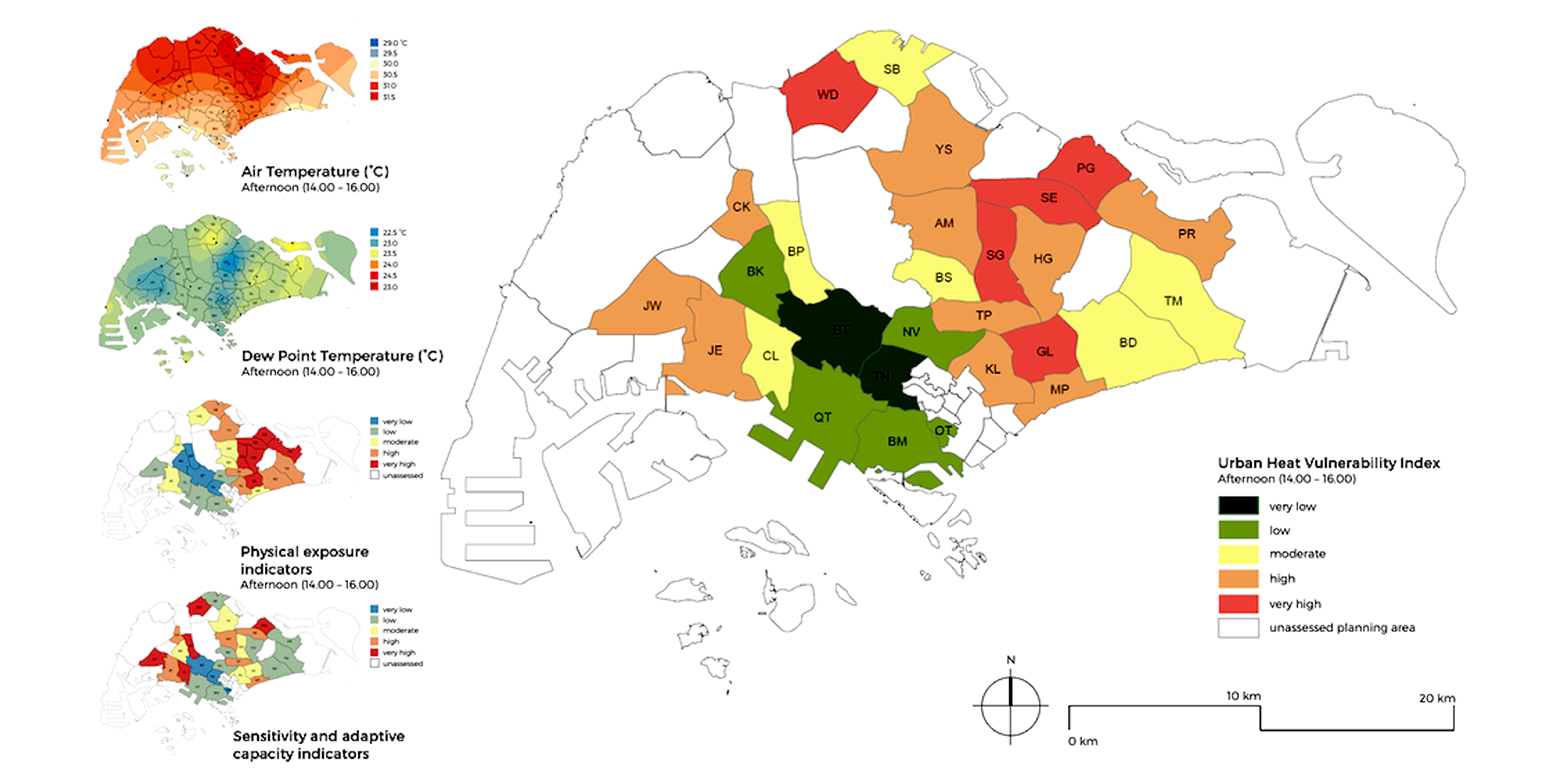
In this study, Dr Conrad Philipp, senior researcher and external page Prof. Winston Chow, principal investigator of Cooling Singapore, investigated the spatial distribution of vulnerability to heat exposure in Singapore for the hottest period of the day, 2 - 4 pm (SGT) as well as for the coldest hour of the day, 7am (SGT) by conducting a UHV analysis in Singapore.
For the UHV analysis, the researchers identified indicators of physical exposure, demographic sensitivity and socio-economic adaptability to urban heat in Singapore. The indicators were then normalised and given equal weight to form an index of physical exposure, sensitivity and adaptive capacity.
Upon completing the UHV analysis, the measurements were summarised and translated into an UHV map and the areas with the highest UHV were defined as risk areas or hotspots. The planning areas in Singapore were summarised into three hotspots (Geylang, Jurong East, and Marine Parade) in the coolest hour of the day, and five hotspots (Geylang, Punggol, Sengkang, and Serangoon, and Woodlands) in the hottest hours of the day.
This analysis provides information that can be useful for emergency management, hazard reduction, public policy and community education. The vulnerability map maps both the known and likely impacts of hazard events and the socio-economic characteristics of the population.
The findings from this study are useful to identify areas where heat mitigation measures are needed most and also areas with the highest levels of social disadvantages and environmental hazards. This identification then aids in the development of suitable heat mitigation strategies to protect the vulnerable population. In addition, the UHV map can support planners to strategically plan wind corridors, location of green areas and urban density across the city.
For full details, read the report external page "Urban Heat Vulnerability Analysis for Singapore" published by the Singapore-ETH Centre.